Monitoring is the basic App which commonly used for general tasks:
User assets are listed in the Object list. It's a small window on the map which can be resized and moved within the screen.
You can also collapse and expand Object list when needed. For doing it, simply click on the arrow sign in its header.
When you select one or multiple items in the object list, three tool buttons appear below the list:
You will get the context menu it contains links to the tools from other Apps which you can apply to the selected object.
We provide wide set of tools to work with maps, addresses, tags, POIs, geofences, directions and many other items which have relation to visualisation of assets and geospatial information.
Basic map toolbar is located in the bottom of the screen.
The platform can easily create a route between two addresses or points on the map. It is possible within the same city as well as between different places.
To create a route you are to point its start and its end. The system will create a route automatically. In case you need to make the route more exact, you should point one or several intermediate places drugging the middle of a route.
You have a possibility to create a route to the chosen object. The route will be built to a particular place showing distance and average time. This function helps to indicate arrival time to the address. It is very helpful in case you need to estimate time from current destination to any desired place, for example if you are waiting for internet shop's order or food delivery, you will be able to see its arrival time.
"Route to this point" function is based on geo - data from different geo-coders. The geo-coder can be set up in your account settings. The default geo-coder is "OSM"
Points of Interest (POI) is a very useful feature as for organizations so for end users. Any user can create a list of POIs for his or her convenience - it can be just a couple of places (like home, work, supermarket, etc.) or include thousands of POIs (for needs of the logistic manager).
You can use directions to find the shortest route between two or more locations. The same tool can also be used in the Route deviation rule to control a vehicle keeps going the predefined way without deviating from it.
When you are going somewhere you have not been before, it's not only about getting the direction there, but also about understanding how that place looks like. Imagine you send your driver to pick some goods. Then you should probably make preliminary research is there enough space for the truck or what is the road surface quality there.
Geofence is a virtual perimeter for a real geographic area.
Geofences are used to define virtual perimeters. The system can control whether object crossed geofence border (either "in" or "out"). All these events are logged, so user can obtain geofence reports and receive alerts.
Moreover, you can assign various rules for events to particular geofences. For example, if you need to get speeding alerts only within a certain area (e.g. in city) or route.
There are three basic types of geofences available:
You have a possibility to colour created geofences for better visualization. It is very helpful in case you have a lot of geofences on the map. So you are able to divide them into groups and distinguish them at a glance. For example, offices may be painted in red, warehouses in blue and parkings in grey.
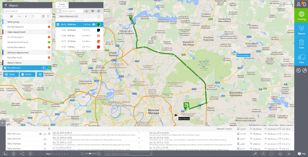
Track view is one of the basic tools commonly used to see the location history. We provide powerful and easy way to view tracks for the chosen date and time range.
You can retrieve track list and view those tracks on the map - for any date range under the limitation according to your tariff plan.
Besides the possibility to save your tracks as KML-files, you may print them on a map. Printed route will be a great supplement to any report (about tracks, fuel consumption etc.). It is very useful for any kind of enterprise that works with delivering, cargo and passenger transportation or mobile staff.
Those events which were registered according to the Rules set by customer, can be viewed on the map in Monitoring app and in Reports app. In this section we explain how to view them on the map.
You can retrieve event list and view them on the map for any data range under the limitations of your tariff plan.
Time Machine is a tool which allows you to playback the history of movement of your assets for any chosen date - as though you travel in the past.